Document 6: Together with a Geometric Drawing
Survey drawing accompanying Document 6
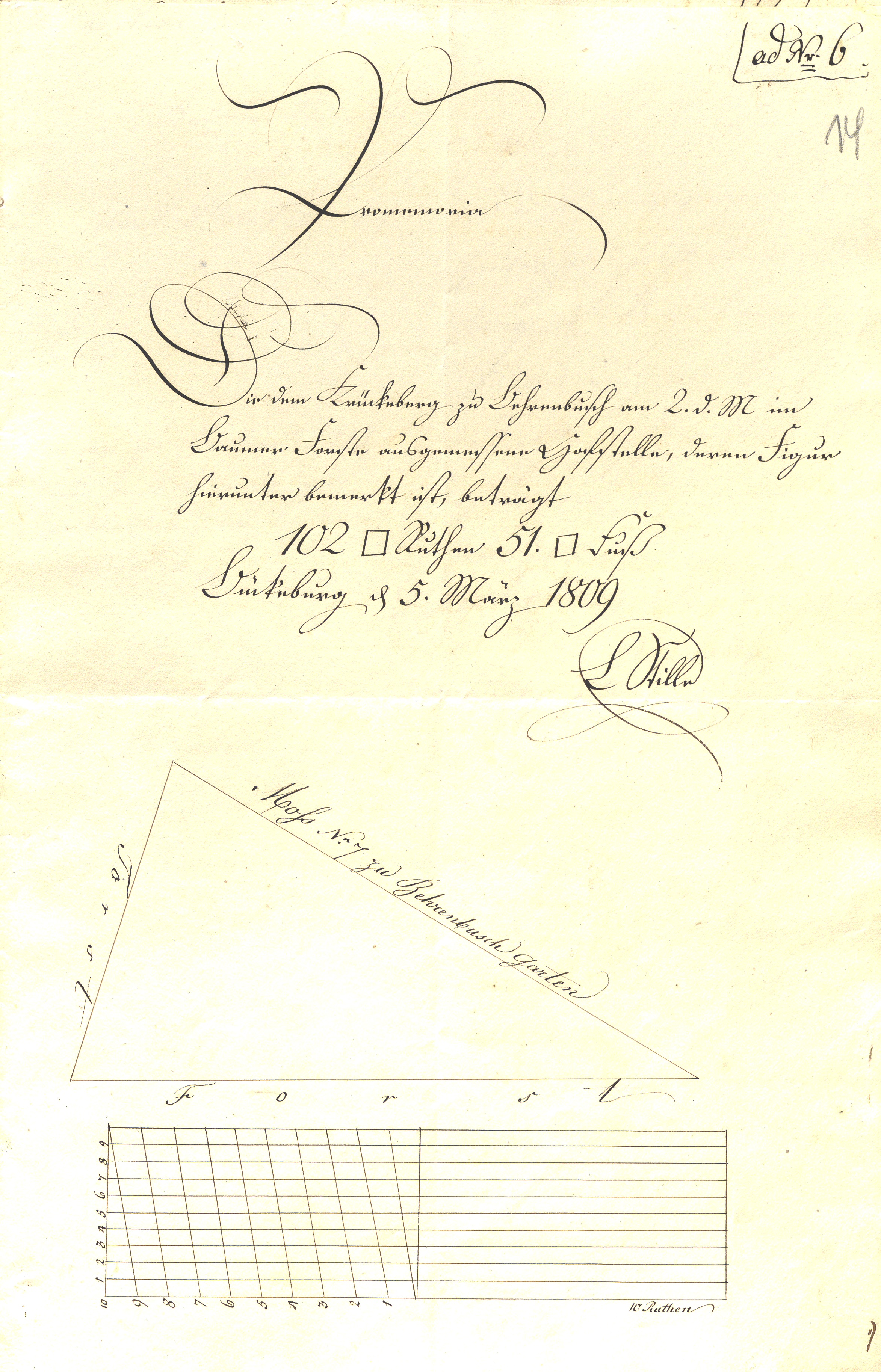
This geometric sketch shows the shape and measured dimensions of the Hofstelle allotted to Jobst Heinrich Krückeberg at Berenbusch. A Hofstelle was a designated building site or homestead plot, including the ground on which a house and its immediate outbuildings could be erected. In early-19th-century Schaumburg-Lippe, a Hofstelle usually did not imply full ownership of the land, but rather the right to occupy and use it as part of a tenancy.
The triangular figure represents the surveyed plot as measured in the Baumer Forest on 2 March 1809. The side lengths are recorded directly on the drawing, and the total area is stated as 102 square rods and 51 square feet.
Such sketches served as supporting documentation for Rentkammer decisions and confirmed that the land allocation had been formally surveyed and approved.
The geometric drawing also shows what borders each side of the property: the forest is on two sides and the garden of #7 Berenbusch is on the third side.
|
Historical land-measurement units. The area of the surveyed Hofstelle is given in Quadrat-Ruthen (squre rods) and Quadrat-Fuß (square fee), which were standard units of land measurement in Schaumburg-Lippe at the beginning of the 19th century. A Ruthe (rod) was a linear measure used in surveying; its square (Quadrat-Ruthe) served as a conventional unit for expressing land area. Quadrat-Fuß (square feet) were used to express residual area below a full Quadrat-Ruthe. The combination of both units reflects customary administrative practice and indicates a formally executed and validated survey rather than an approximate estimation. |
Transliteration and Translation
Survey Text
ad Nr. 6


Cromemoria

Die dem Krückeberg zu Behrenbusch am 2. d. M im
Baumer Forste ausgemessene Hofstelle, deren Figur
hierunter bemerkt ist, beträgt
102 Quadrat Ruthen 51. Quadrat Fuß
Bückeburg d[en] 5. März 1809.

L Stille
ad No. 6 (with reference to document no. 6)

Memorandum

The house site measured for Krückeberg at Berenbusch on the 2nd of the
current month in the Baumer Forest, the figure of which is noted
below, amounts to
102 square rods and 51 square feet.

Bückeburg, the 5th of March 1809.

L. Stille
Boundary Labels
The drawing is of the new future site to be allocated to Jobst Heinrich Krückeberg, which will be site no. 18 at Berenbusch. The labels in the drawing indicate the bordering areas. It is bordered on two sides by foresst (Forst) and on one side by the garden (Garetn) of site no. 7 at Berenbusch.
| German | English Meaning |
|---|---|
Hofs No. 7 zu Behrenbusch Garten |
(This side) borders the garden of site no. 7 at Berenbusch |
Forst |
(This side) borders the forest |